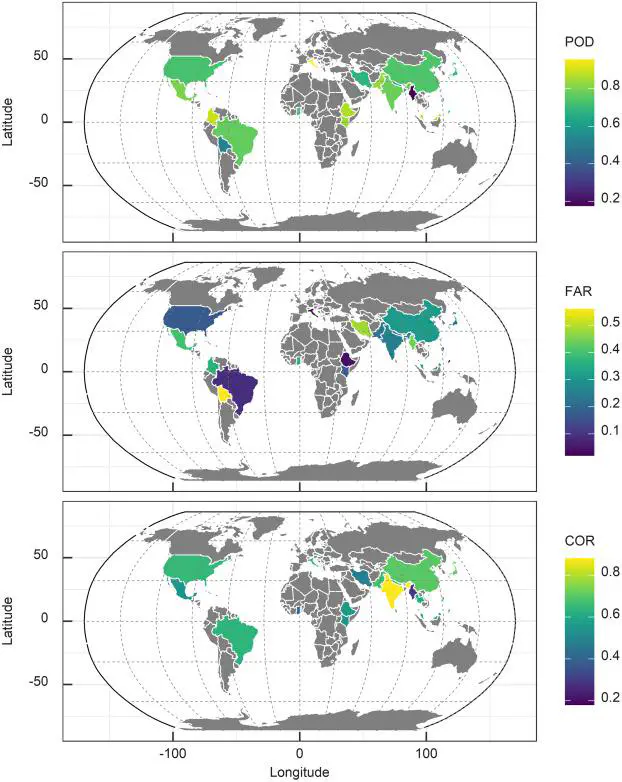
 Spatial distribution of POD, FAR, and correlation values of IMERG evaluation studies across the countries at daily scale.
Abstract
Accurate, reliable, and high spatio-temporal resolution precipitation data are vital for many applications, including the study of extreme events, hydrological modeling, water resource management, and weather and climate research in general. In this study, we examined the available literature up to 2019 to review the performance of the Integrated Multi-Satellite Retrievals for GPM (IMERG) products. We assessed the performance across different geographical locations and climatic conditions around the globe. Also, in terms of extreme precipitation and hydrological utility. Asia, and in particular China, concentrates the largest number of IMERG evaluation studies on the continental and country level. The performance of IMERG varies with seasons, precipitation type, structure, and intensities. IMERG is shown to appropriately estimate and detect regional precipitation patterns, and their spatial mean. There is sufficient room to improve its performance over mountainous regions characterized by orographic precipitation, complex terrains, and winter precipitation. Furthermore, despite IMERG’s better performance compared to other satellite products in reproducing spatio-temporal patterns and variability of extreme precipitation, some studies present limitations surrounding the intensity of precipitation, showing significant under- and overestimation. In terms of temporal performance, at the seasonal scale, IMERG behaves poorly in winter, whereas the performances at monthly and annual scale were reasonably better than the daily and sub-daily scale. However, we also report very few sub-daily studies, particularly at 30-min scale. Finally, in terms of hydrological application, the use of IMERG has resulted in significant discrepancies in the simulation of streamflow. Despite its current limitations, IMERG shows promising results as new versions substitute the previous ones, strengthening the wide range of the potential applications.