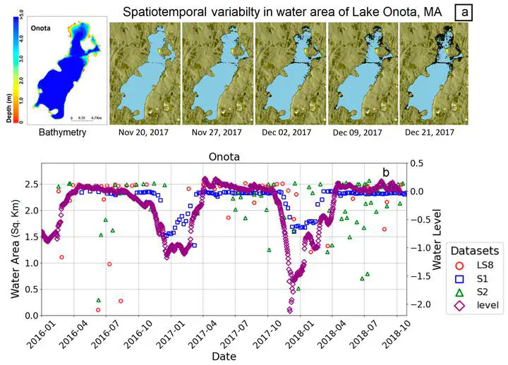
Abstract
Artificial manipulation of lake water levels through practices like winter water-level drawdown (WD) is prevalent across many regions, but the spatio-temporal patterns are not well documented due to limited in-situ monitoring. Multi-sensor satellite remote sensing provides an opportunity to map and analyze drawdown frequency and metrics (timing, magnitude, duration) at broad scales. This study developed a cloud-computing framework to process time-series of synthetic aperture radar (Sentinel 1-SAR) and optical sensor (Landsat-8, Sentinel-2) data to characterize WD in 166 lakes across Massachusetts, USA from 2016‒2021. Comparison with in-situ logger data showed Sentinel-1 derived surface water area captured relative water level fluctuations indicative of WD. A machine learning approach classified lakes as WD versus non-WD based on seasonal water-level fluctuations derived from Sentinel 1-SAR data. The framework mapped WD lakes statewide, revealing prevalence throughout Massachusetts with interannual variability. Results showed WDs occurred in over 75% of lakes during the study period, with high interannual variability in number of lakes conducting WD. Mean WD magnitude was highest in the wettest year (2018) but % lake area exposure did not show any association with precipitation and varied between 8% to 12% over 5-year period. WD start date was later and duration was longer in wet, indicating climate mediation of WD implementation driven by management decisions. The data and tools developed provide an objective information resource to evaluate ecological impacts and guide management of this prevalent but understudied phenomenon. Overall, the results and interactive web tool developed under this study provide new hydrologic intelligence to inform water management and policies related to WD practices.