Combining big-data remote sensing and global hydrologic modelling improves daily discharge estimates across an entire large watershed
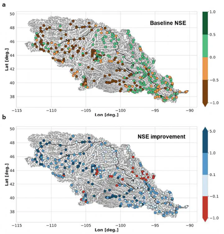 Spatial distribution of the a) baseline NSE and b) NSE improvements over Missouri Basin. Thick black lines show BAM reaches. We see most large improvement (dark blue) upstream, where original NSEs were poor. The downstream reaches were well modeled in the baseline already, and we made almost no improvement but did no harm.
Abstract
Remote sensing has gained attention as a novel source of primary information for estimating river discharge, and the Mass conserved Flow Law Inversion (McFLI) approach has successfully estimated river discharge in ungauged basins solely from optical satellite data. However, McFLI currently suffers from two major drawbacks: 1) Existing optical satellites lead to temporally and spatially sparse discharge estimates, and 2) because of the assumptions required, McFLI cannot guarantee downstream flow continuity. Hydrological modeling has neither drawback, yet model accuracy is frequently limited by a lack of discharge observations. We therefore combine McFLI and models in a data assimilation framework applicable globally. We establish a daily “ungauged” baseline model for 28,998 reaches of the Missouri river basin forced by recently published global runoff data, which we do not calibrate. We estimate discharge via McFLI using ~1 million width measurements made from 12,000 Landsat scenes and assimilate McFLI into the model before validating at 403 USGS gauges. Results show that assimilated discharges did not impair already accurate baseline flows and achieved median improvements of 28% Normalized Root Mean Square Error (NRMSE), 0.50 Nash-Sutcliffe Efficiency (NSE), and 0.23 Kling-Gupta Efficiency (KGE) where baseline performance was poor (defined as baseline negative NSE, 225/403 reaches). We ultimately improved flows at 92% of these originally poorly modelled gauges, even though Landsat images only provide McFLI discharges at 1.5% of reaches and 26% of simulated days. Our results suggest that the combination of McFLI and state-of-the-art hydrology models can improve flow estimations in ungauged basins globally.