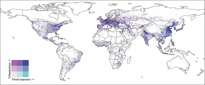
 Global map of urbanization and flood exposure during 1985-2015.
Abstract
Cities have historically developed close to rivers and coasts, increasing human exposure to flooding. That exposure is exacerbated by changes in climate and population, and by urban encroachment on floodplains. Although the mechanisms of how urbanization affects flooding are relatively well understood, there have been limited efforts to assess the magnitude of floodplain encroachment globally and how it has changed in both space and time. Highly resolved global datasets of both flood risk and changes in urban area from 1985-2015 are now available, enabling the reconstruction of the history of floodplain encroachment at high spatial resolutions. Here we show that the urbanized area in floodplains that have an average probability of flooding of 1/100 years, has almost doubled since 1985. Further, the rate of urban expansion into these floodplains increased by a factor of 1.5 after the year 2000. We also find that urbanization rates were highest in the most hazardous areas of floodplains, with population growth in these urban floodplains suggesting an accompanying increase in population density. These results reveal the scope, trajectory and extent of global floodplain encroachment. With tangible implications for flood risk management, these data can be directly used with integrated models to assess adaptation pathways for urban flooding.