Abstract
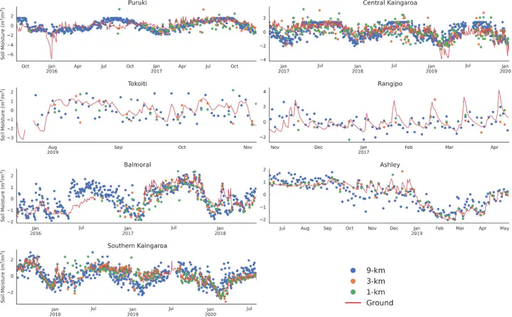
Quantifying the availability of soil moisture in forested environments has many implications for their ecosystem, and therefore the ability to map its dynamics accurately becomes important. Remote sensing offers the only viable strategy for cost-effective, global measurements of soil moisture and the launch of satellites with L-band microwave sensors such as the Soil Moisture Active Passive (SMAP) has extended those capabilities to forested areas. A number of retrieval algorithms have been developed by the SMAP mission that have generated multi-scale data products at 9 km, 3 and 1 km with the two finer-scale datasets derived by combining SMAP and Sentinel-1 C-band observations. In this study, we evaluated the ability of the three SMAP products to estimate the magnitude and dynamics of soil moisture in a relatively challenging environment of dense forest cover and topographic complexity using ground measurements from seven sites in New Zealand. We found that the finer-scale products had an overall smaller error and higher correlations when compared with the ground measurements, but did exhibit noise especially as canopy closure increased. On the other hand, the 9-km product had larger errors but was still able to capture the temporal dynamics of soil moisture. Our results are consistent with recent studies evaluating SMAP in forested environments, and the improved performance of the finer-scale products suggests a pathway towards accurate estimates of forested soil moisture using multi-scale data fusion.