Computational Hydrology Research Group at the University of Massachusetts Amherst
Welcome to Hydro@UMass!
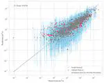
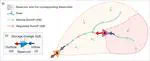
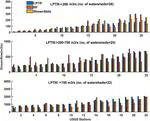
This is the webpage of the Computational hydrology Research Group in the Civil and Environmental Engineering department at the University of Massachusetts Amherst. The group is led by Kostas Andreadis, and the research that we do focuses on the intersection of water resources modeling, remote sensing and in-situ observations, data fusion, and the study of large-scale hydrology as it relates to climate change and environmental monitoring.
We study the use of remote sensing (both satellite and airborne) to monitor freshwater resources globally.
We develop and implement numerical models to better understand hydrologic processes at multiple scales, and software tools to facilitate their use in applications.
We develop data assimilation and machine learning algorithms to integrate models and observations for improving hydrologic prediction and uncertainty characterization.
Floods are one of the costliest natural disasters both in terms of damages and human livelihood losses. Urban encroachment on floodplains increases exposure and vulnerability to floods while population changes and climate change are expected to exacerbate those risks.
Rice is Asia’s most important food crop with nearly 3 billion people reliant on rice as their major food source. Over the next ten years this number is expected to climb to nearly 4 billion people.
Human acceleration of eutrophication through continued watershed and lakeshore development, combined with changes in temperature and climate, increasingly challenges managers to meet human needs while protecting aquatic resources. While annual winter water level drawdowns (WDs) are commonly used to reduce nuisance macrophyte biomass, the future utility and impacts to ecosystems under climate change remains uncertain.
Snow accumulation and its melt dominate water resources in mountainous areas, with regions such as the western United States deriving more than 75% of the total freshwater available annually from snowmelt.
The SWOT satellite mission will observe water surface elevation, slope, storage change (directly) and river discharge (indirectly) globally at unprecedented spatial resolutions and accuracies, potentially having a “transformational impact in terrestrial hydrology”.
As climate change is impacting the future of aquatic flows, there is a great need for natural resource managers to assess adaptation measures in a holistic manner. The latter requires integrating multiple models with observational data, but that can be problematic due to disparities in terms of scale or fidelity of each model.